Who We Are
US CLIVAR is a national research program with a mission to foster understanding and prediction of climate variability and change on intraseasonal-to-centennial timescales, through observations and modeling with emphasis on the role of the ocean and its interaction with other elements of the Earth system, and to serve the climate community and society through the coordination and facilitation of research on outstanding climate questions.
Our Research
The ocean plays a key role in providing a major long-term "memory" for the climate system, generating or enhancing variability on a range of climatic timescales. Understanding the ocean's role in climate variability is therefore crucial for quantifying and harnessing the predictability inherent to the Earth system. US CLIVAR-led research has played a substantial role in advancing understanding of, and skill in predicting climate variability and change.
Science and Research Challenges

Subseasonal-to-
Seasonal Prediction

Decadal Variability
and Predictability

Climate Change

Climate and Extreme
Events

Polar Climate Changes

Climate and Marine
Carbon/Biogeochemistry

Climate at the Coasts
Announcements
US CLIVAR-Related Sessions at the 2027 Annual AMS Meeting
Abstract submission deadlines is Tuesday, August 11, and will not be extended.
US CLIVAR-Related Sessions at the Fall 2026 AGU Meeting
Submit an abstract by August 5 to connect with experts in the Earth and climate community.
June Newsgram is Available
Stay informed with the latest news, research highlights, webinars, data sets, meetings, funding, career opportunities, and jobs for the climate science community.
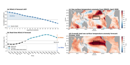
Simple ocean-based model shows El Niño forecast skill and points to a strong event ahead
Wang et al. (2026) present the Wyrtki CycloStationary Linear Inverse Model (Wyrtki-CSLIM), which leverages Wyrtki and Hasselmann memory to demonstrate that skillful ENSO forecasts can be generated up to 15 months in advance.
Upcoming Webinars
There are no upcoming Webinars at this time.