Can we predict seasonal changes in high impact weather in the US?
Eunsil
Jung
University of Miami
Poster
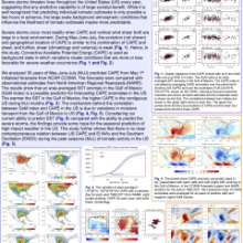
The ability to predict severe weather has great societal value. It is well known that individual tornado outbreaks are predictable only several hours in advance. However, it may be possible to predict the seasonal changes in the environmental conditions that support tornado outbreaks. Essentially, we ask “can we predict changes in the likelihood of tornedo outbreak?” Here we use the NCAR Community Climate System Model version 4.0 (CCSM4) forecasts from the North American Multi-Model Ensemble (NMME), and observational estimates from North American Regional Reanalysis (NARR) for the period 1982-2011. This study shows that the Convective Available Potential Energy (CAPE), as the background state that is a more favorable condition for high impact weather in the United States, is strongly correlated with sea surface temperature in the Gulf of Mexico during the peak seasons of tornado outbreaks. In contrast, no contemporaneous relations are found with El Niño Southern Oscillation.
Poster 19.pdf
(2.87 MB)
Session III: Weather and climate extremes in the Americas
Number of comments: 11
Comments
Comment by: Suz Tolwinski-Ward
September 2, 2015 - 6:47am
Given recent results from Allen et al (http://www.nature.com/ngeo/journal/v8/n4/full/ngeo2385.html), I'm curious whether you might use the same analysis and find any relationship between MJJ CAPE and *antecedent* winter ENSO conditions. Also, what do you think the best use is of this kind of prediction of enhanced/suppressed background conditions influencing the likelihood of severe weather over large regions for social resilience (in contrast to actual forecasts of severe weather on local scales)?
Comment by: eunsil Jung
September 3, 2015 - 11:22am
First question: Thanks for the suggestion. We did not examine the lag/lead relations between ENSO and MJJ CAPE yet
(According to Lee et al (2013) doi:http://dx.doi.org/10.1175/JCLI-D-12-00128.1), TransNino pattern is shown during the top 10 tornado active years (April-May), with no consistent El-Nino or La-Nina years (Table 3))
For the second question, it is a great question. We could encourage people to well-prepare for the tornado in the year of warmer SST in the Gulf of Mexico.
Comment by: Vasu Misra
September 2, 2015 - 2:52pm
Very interesting work. Shows lot of promise. Figs. 1a and b show some relation between CAPE and tornado outbreaks. But do the anomalies also similar relationship i.e., CAPE anomalies relate to anomalies of number of tornadoes?
Comment by: eunsil jung
September 3, 2015 - 11:23am
Yes they do. We looked the accumulated (and mean) tornado numbers and CAPE with calendar days, and the anomalously large CAPE years were consistent with active-tornado years (e.g., anomalously large CAPE during tornado active year of 2011 and anomalously low CAPE during inactive tornado year of 1988)
Comment by: Lakshmi Krishna...
September 11, 2015 - 9:32am
ENSO has significant influence on the Gulf of Mexico SSTs in spring and as your results show that US CAPE is related to Gulf of Mexico SSTs. It is intriguing that you dont find a relationship between US CAPE and ENSO. Do you have any insights on why this is the case?
Comment by: eunsil jung
September 11, 2015 - 10:59am
I think, this is because the data period that we used (May-June-July). During this period, we did not find any linear relationships between US CAPE and ENSO as well as Nino 3.4 SST and Gulf of Mexico SST (not shown). FYI, we detrended SST in this study to remove the global warming effect.
Comment by: eunsil jung
September 11, 2015 - 10:55am
I think, this is because the data period that we used (May-June-July). During this period, we did not find any linear relationships between US CAPE and ENSO as well as Nino 3.4 SST and Gulf of Mexico SST (not shown). FYI, we detrended SST in this study to remove the global warming effect.
Comment by: eunsil jung
September 11, 2015 - 11:00am
Sorry this is a reply for the previous comment
Comment by: Sang-Ki Lee
September 11, 2015 - 1:00pm
I understand that Nino3.4(MJJ) and GoM SST(MJJ) has a very little correlation. But, Nino3.4(DJF) and GoM SST(MJJ) could be negatively correlated (although weak). Sang-Ki
Comment by: eunsil jung
September 11, 2015 - 1:04pm
Thanks for your suggestion. Yes. that's true. In this study we did not look at the relationship between the previous winter (DJF) and MJJ.
Comment by: Anonymous
September 11, 2015 - 1:32pm
I also see a dipole pattern of CAPE between GoM and Caribbean Sea. Given that CAPE is very sensitive to SST, this is consistent with a typical remote ENSO influence on the tropical Atlantic. The remote influence on IAS SST peaks in MAM and dissipates quickly in MJJ. But, with a strong and persistent El Nino, the influence may persist throughout MJJ. Of course, Atlantic has its own internal variability, which may interfere with such relationship. In any case, it appears that linking GoM SST with US tornado activity is more effective in MJJ. Nice work! - Sang-Ki
Not accepting new comments