A typology of convection regimes observed over the Caribbean from May to November
Nicolas
Vigaud
International Research Institute (IRI)
Poster
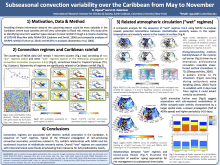
A cluster analysis applied on 1980-2009 NOAA daily Outgoing Longwave Radiation (OLR) reveals, for the May to November rainy season, seven recurrent convection regimes in the Caribbean. Two of them, found to be associated with large-scale drying, are characterized by the establishment of high pressure anomalies over the basin, related to anomalous moisture export towards the eastern Pacific and weakened trades in the tropical Atlantic, both reducing local moisture convergence/availability and thus convection. The other regimes belong to a common sequence typical of rainfall-producing convective cells propagating across the Caribbean basin. Two regimes offer distinct scenarios for their growth, while the remaining three are related to their northwestward propagation and exhibit substantial linkages with SSTs in the eastern Pacific and North Atlantic; Nevertheless, warm pre-conditioning in the tropical Atlantic/Caribbean basin seems to favor their early development phase. Associated convective episodes, some of which were related to major hurricanes that brought devastating damages in the region (Opal in 1995, Ivan in 2004, Dennis/Wilma in 2005, Ike in 2008), can often be traced to African Easterly Wave precursors. However, their growth is found to be strongly influenced by the southward incursion of upper-level westerly waves from the midlatitudes, highlighting the importance of tropical-temperate interactions over the Caribbean for the May-November period. Substantial relationships between “wet” regimes and flood episodes over the Caribbean (Caribbean Disaster Impacts and Preparedness database) suggest potentials from weather typing approaches for regional disaster risk management.
Poster 23.pdf
(8.24 MB)
Session III: Weather and climate extremes in the Americas
Number of comments: 2
Comments
Comment by: Vasu Misra
September 11, 2015 - 1:01pm
Hi Nicolas,
Any of the 5 wet regimes that could explain the bimodal peaks in rainfall over Central America and western Caribbean. I would believe the first of the two bimodal peaks in May-June is too early for tropical-mid-latitude interaction to happen consistently?
Are you also implying that the absence of tropical-midlatitude interaction gives rise to "dry regime" types?
Comment by: Nicolas Vigaud
September 11, 2015 - 1:35pm
Greetings Vasu and thanks for your interest.
Dry regimes 2 and 4 seem to dominate the May-Nov period and be more frequent during Jul-Sep to the detriment of wet regimes 3, 6 and 5 most particularly, hence agreeing with a rainfall break. On the other hand, wet regime 3, at the beginning of the sequence we describe in the poster, seems to be more frequent for the second peak compared to May-Jun which actually supports your guess. To answer your second question, this same wet regimes 3-6-5 sequence displays tropical-midlatitude interactions in which easterly waves could be seen as seeds of convection transiting westwards which midlatitude westerly waves can cap, hook and sustain in their transition across the Caribbean basin. In this sense, the midlatitude component could be a necessary ingredient for the most rainfall-producing episodes but not all, i.e. regimes 1 most frequent during the first peak. On the other hand, dry regimes do not show similar wave-like pattern in the upper-troposphere, rather high pressure anomalies at surface and sustained subsidence, thus I do not think these results would imply the above. At this stage, I still need to fully examine the stratification of the circulation anomalies along the season and your input are well precious, thanks!
Not accepting new comments