Characteristics of Tropical Cyclones Making Landfall on the Pacific Coast of Mexico: 1970-2014
Luis M.
Farfán
Center for Scientific Research and Higher Education at Ensenada (CICESE)
Poster
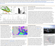
This study evaluates impacts from tropical cyclone (TC) landfalls on populated areas located along the Pacific Ocean coast of Mexico. The period of interest is from 1970 through 2014 and an international disaster database is used to identify the impact from landfalling tropical cyclones. We examined the top 25 TCs based on rainfall accumulation, as well as the top 10 TC-related disasters based on surveys with at least 100 people affected. Strong winds and heavy rainfall, are associated with property damage and loss of lives. Our results indicate that excessive rainfall accumulations and daily rates, over highly populated areas, are essential elements associated with the occurrence of disasters. A sample of case studies that occurred during the whole period are documented as they affected areas with different population densities in the southern and northwestern coasts. The documentation includes observations from hurricane Pauline in 1997 as well as forecast products from hurricanes Jimena in 2009, Manuel in 2013, and Odile in 2014.
Poster 18.pdf
(760.41 KB)
Session III: Weather and climate extremes in the Americas
Number of comments: 6
Comments
Comment by: Suz Tolwinski-Ward
August 28, 2015 - 10:43am
What kind of challenges and uncertainties are associated with each of the data sets used in this study? It seems your work seeks to tie together information about terrain, population, TC severity and location, and precipitation intensity. I assume that the terrain data set, census information, TC monitoring platforms, and network of rain gauges each may have heterogeneous spatial coverage, time-dependent uncertainty, limited precision, etc. I'm much less familiar with the data sets for Mexico than I am for the U.S., and am curious which of them poses the most challenges to quantifying the relationships between various measures of storm intensity and impacts.
Comment by: Luis M Farfán
September 6, 2015 - 4:28pm
The data sets we used have limitations. For example, most rain-gauge accumulations are derived from 24-hour reports manually taken from scattered locations along the coastal states. This does not allow to know rates for shorter time periods such as hours or minutes. In general, during the study period, there are few weather stations that included wind sensors to have more accurate measurements of the storm intensity and structure. The population counts, from the Mexican government, are performed every 5-10 years but we were not able to determine the population distribution at the time of every landfall event or how this distribution changed just after the event. Another challenge was to determine the number of affected people and deaths directly related to each tropical cyclone. Here, we decided to apply a reliable data base (EM-DAT) that compiles information from various sources including government agencies, insurance companies, research institutes and press agencies.
Comment by: Vasu Misra
September 2, 2015 - 2:26pm
I am curious to know the reasons for different conclusions on the influence of ENSO on TC activity in Mexico. A poster by Dominguez and Magana (in this session), suggest that the TC clusters making most land fall both from the Caribbean coast as well as from the East Pacific coast is associated with LaNina, with one particular cluster of tracks from E. Pacific affecting Southwestern Mexico is associated with El Nino. In your case are you picking only this cluster that affects landfall in southwestern Mexico or 10 extreme events a small sample size to draw a conclusion on the large-scale SST anomalies?
Comment by: Luis M Farfán
September 7, 2015 - 9:34pm
Thanks for your comment and interest in our poster. With respect to tropical cyclones affecting the west coast of Mexico, the study is based on a particular set of 10 events that caused the largest impact on the population from 1970 through 2014. We used the Oceanic Niño Index (ONI) to identify El Niño, La Niña and neutral phases. Most of these tropical cyclones developed during El Niño (6 out of 10 times) or neutral (3 times) conditions. I believe that the poster by Dominguez and Magaña (the composites in their Figure 3) states that the tropical cyclone formation in the Eastern North Pacific (ENP) is influenced by warm ENSO phases during the period 1979-2009. The corresponding cluster has tracks moving westward while some of them made landfall in Mexico, as seen in their Figure 1B. The ENP clusters (their Figure 1A-D) seem to have more members (with both landfalling and non-landfalling tracks) which leads to results that may not be consistent with our conclusion. Also, note that the SST anomalies are from a daily basis computation (the cyclogenesis day) while the ONI is defined for a three-month running mean within a region bounded by 5⁰N-5⁰S and 120-170⁰W that is partially seen in their Figure 3.
Comment by: Christian Dominguez
September 11, 2015 - 12:26pm
Interesting poster!
It's my understanding that the Mexican TC warning system has been working since the year of 2000. Unfortunately, TC Manuel and Ingrid showed that several actions are still missing. My question is: Has the state of Baja California considered to create a special LOCAL TC warning system? I mean, have additional efforts to face TCs been implemented in Baja California apart from the national procedures?
Comment by: Luis M Farfan
September 11, 2015 - 5:34pm
The regional goverment in the southern Baja California peninsula has not
considered a warning system beyond the information issued by the
Mexican Meteorological Service. However, we are in transition to
have a new state government and this may be an opportunity to
see changes during the next few tropical cyclone seasons.
Not accepting new comments