Interlinking Climate Extremes: Analyzing the Impact of European Heatwaves on Pakistan's Monsoon Rains in 2010 and 2022
Abhinav
Dengri
Hokkaido University, Japan
Poster
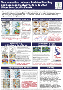
In 2022, Pakistan experienced an unprecedented level of monsoonal rains, resulting in over 1,500 fatalities and displacing more than 30 million people. This catastrophe paralleled the 2010 floods in terms of its scale of devastation. Both 2010 and 2022 witnessed extreme heatwaves in mid-latitude regions, particularly in Western Europe. Our study focuses on comparing the spatial and temporal patterns of rainfall in Pakistan during these years, as well as examining the interaction between tropical and extratropical systems.
The peak of heavy rainfall in 2010 occurred in Northern Pakistan in late July. In contrast, 2022 saw not only Northern Pakistan but also the typically hot, arid desert of Southern Pakistan receiving unprecedented rainfall, exceeding 800mm during the July-August period, with the peak in late August. This was the highest recorded rainfall in Southern Pakistan to date. Additionally, surface temperatures over Western Russia in late July 2010 and late August 2022 surged by more than 8 degrees Celsius, coinciding with Rossby Wave breaking events. These events facilitated the transport of cold, high potential vorticity (PV) stratospheric air from deep troughs towards Pakistan. In 2022, the reach of this high PV cold stratospheric air extended further south compared to 2010, affecting Southern Pakistan, whereas in 2010, its impact was confined to Northern Pakistan. Furthermore, our analysis indicates that during these periods, substantial moisture was conveyed to these regions by anomalous southerly winds from the Arabian Sea. In 2010, the presence of two mid-tropospheric cyclonic systems, one east of Pakistan and another in the south, aided in directing moisture towards Northern Pakistan, a scenario not observed in 2022. These extratropical disturbances induced atmospheric instability, leading to the ascent of moist and warm air over the region, which in turn resulted in heavy rainfall.
The peak of heavy rainfall in 2010 occurred in Northern Pakistan in late July. In contrast, 2022 saw not only Northern Pakistan but also the typically hot, arid desert of Southern Pakistan receiving unprecedented rainfall, exceeding 800mm during the July-August period, with the peak in late August. This was the highest recorded rainfall in Southern Pakistan to date. Additionally, surface temperatures over Western Russia in late July 2010 and late August 2022 surged by more than 8 degrees Celsius, coinciding with Rossby Wave breaking events. These events facilitated the transport of cold, high potential vorticity (PV) stratospheric air from deep troughs towards Pakistan. In 2022, the reach of this high PV cold stratospheric air extended further south compared to 2010, affecting Southern Pakistan, whereas in 2010, its impact was confined to Northern Pakistan. Furthermore, our analysis indicates that during these periods, substantial moisture was conveyed to these regions by anomalous southerly winds from the Arabian Sea. In 2010, the presence of two mid-tropospheric cyclonic systems, one east of Pakistan and another in the south, aided in directing moisture towards Northern Pakistan, a scenario not observed in 2022. These extratropical disturbances induced atmospheric instability, leading to the ascent of moist and warm air over the region, which in turn resulted in heavy rainfall.

Poster file
Dengri_Abhianv_blocking_poster.pdf
(2.91 MB)
Meeting homepage
