Simple ocean-based model shows El Niño forecast skill and points to a strong event ahead
The El Niño–Southern Oscillation (ENSO) is a major climate pattern that influences rainfall, temperature, drought, flooding, marine ecosystems, and hazards around the world. Thus, scientists have long worked to improve forecasts of ENSO. A recent study by Wang et al. (2026) shows that skillful ENSO forecasts can be made up to 15 months in advance using a relatively simple model built from ocean surface temperature and sea level information—no complex climate model needed.
The model, called the Wyrtki CycloStationary Linear Inverse Model, or Wyrtki-CSLIM, is a low-order climate model built around two forms of climate memory. The first, called Wyrtki memory, represents the buildup and release of warm upper-ocean water in the equatorial Pacific, a key process in the development of El Niño and La Niña. In the model, this memory is captured using sea level as a proxy for upper-ocean heat content. The second, called Hasselmann memory, represents the persistence of large-scale sea surface temperature patterns across the global ocean. These patterns, including those outside the tropical Pacific, can influence how ENSO evolves months later.
To evaluate the model, the researchers performed retrospective forecasts, examining how well the Wyrtki-CSLIM would have predicted past changes in the Niño3.4 index, a standard measure of ENSO, over six decades of climate conditions. The model produced skillful forecasts out to 15 months and captured the timing and strength of major El Niño and La Niña events. Its performance was comparable to that of the extended nonlinear recharge oscillator, one of the leading low-order ENSO models, and exceeded that of the current operational Linear Inverse Model.
The Wyrtki-CSLIM offers a simple, explainable, and low-cost approach to improve ENSO prediction without relying on computationally expensive climate models. It suggests that Wyrtki and Hasselmann memories are core sources of ENSO predictability, and that future forecasting systems could be improved by more accurately representing these two forms of memory.
The Wyrtki model currently predicts the development of a strong El Niño, up to 3°C warmer than normal over the equatorial eastern Pacific, toward the end of this year.
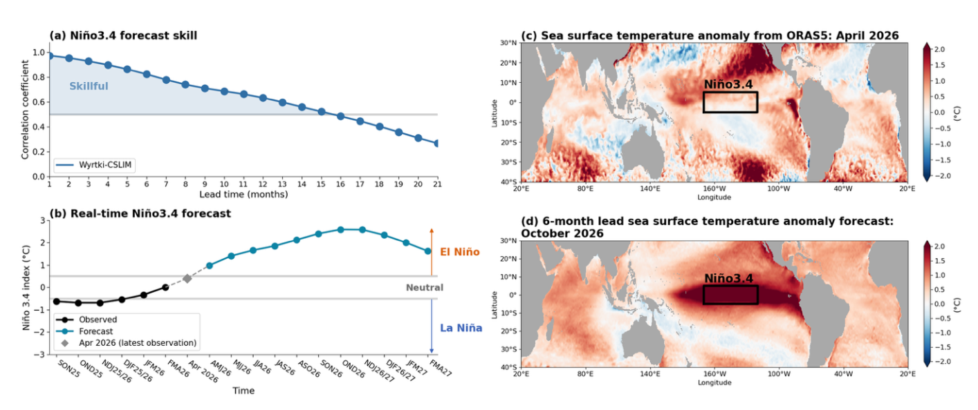
Wyrtki-CSLIM forecast skill and the latest real-time forecast for ENSO. a) Forecast skill of the Niño-3.4 index from the Wyrtki-CSLIM. b) A real-time forecast of the Niño-3.4 index showing that El Niño conditions are likely to develop this year. c) Sea surface temperature anomalies from the ORAS5 ocean reanalysis for April 2026 and d) the corresponding six-month forecast for October 2026 from the research model. The black box in c) and d) marks the Niño3.4 region in the equatorial central Pacific, a key area used to monitor El Niño and La Niña conditions. In April 2026, weak warmer-than-average water conditions were present in the Niño3.4 region, while the October 2026 forecast indicates strong warmer-than-average conditions, consistent with the likely development of El Niño later this year. The forecast is updated monthly online.
Wang, Y., M. J. Widlansky, M. F. Stuecker, S. Zhao, and F. -F. Jin, 2026: ENSO predictability from combined Wyrtki and Hasselmann memory in a cyclostationarylinear inverse model. Geophys. Res. Lett., 53, e2025GL119694, https://doi.org/10.1029/2025GL119694.
Topics
- ENSO
- Modeling
- Ocean Heat
- Pacific Ocean