
Representation of Extreme Wet Events in the Maritime Continent: Insights from High Resolution MESACLIP and NEX-GDDP-CMIP5 CESM Simulations
Donaldi
Donaldi Permana
BMKG
Poster
"Extreme wet events are among the most impactful hydroclimatic hazards in the Maritime Continent, frequently causing floods, landslides, and substantial socio-economic losses. Their occurrence is governed by complex interactions among mesoscale convective systems, topography, land–sea contrasts, monsoonal circulations, and coupled atmosphere–ocean processes, posing significant challenges for climate models.
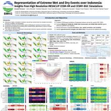
This study evaluates the representation of extreme wet events over the Maritime Continent using high-resolution MESACLIP climate simulations and compares their performance with the CESM-based NEX-GDDP-CMIP5 dataset. Although both datasets have a nominal spatial resolution of approximately 25 km, they are generated through fundamentally different approaches: MESACLIP employs dynamical climate simulations, whereas NEX-GDDP-CMIP5 is derived from statistical downscaling and bias correction of coarse-resolution CMIP5 output.
Extreme precipitation is characterized using selected ETCCDI indices, including Rx1day, Rx5day, R95p, R99p, SDII, and CWD, which are widely used to assess changes in precipitation intensity, frequency, and persistence. Model performance is evaluated against MSWEP, CRU, CHIRPS, and SA-OBS using spatial correlation, root mean square difference (RMSD), mean bias, and standard deviation. Seasonal climatology is further assessed using Taylor-diagram analysis.
Preliminary results indicate that NEX-GDDP-CMIP5 reproduces observed seasonal climatology more accurately than MESACLIP, likely reflecting the influence of statistical downscaling and bias correction. However, MESACLIP may provide added value in representing the magnitude, frequency, persistence, and spatial distribution of extreme wet events through its physically based simulation of mesoscale processes. This study highlights the respective strengths and limitations of dynamical and statistical downscaling approaches and provides insights for climate-risk assessment and adaptation planning across the Maritime Continent."
This study evaluates the representation of extreme wet events over the Maritime Continent using high-resolution MESACLIP climate simulations and compares their performance with the CESM-based NEX-GDDP-CMIP5 dataset. Although both datasets have a nominal spatial resolution of approximately 25 km, they are generated through fundamentally different approaches: MESACLIP employs dynamical climate simulations, whereas NEX-GDDP-CMIP5 is derived from statistical downscaling and bias correction of coarse-resolution CMIP5 output.
Extreme precipitation is characterized using selected ETCCDI indices, including Rx1day, Rx5day, R95p, R99p, SDII, and CWD, which are widely used to assess changes in precipitation intensity, frequency, and persistence. Model performance is evaluated against MSWEP, CRU, CHIRPS, and SA-OBS using spatial correlation, root mean square difference (RMSD), mean bias, and standard deviation. Seasonal climatology is further assessed using Taylor-diagram analysis.
Preliminary results indicate that NEX-GDDP-CMIP5 reproduces observed seasonal climatology more accurately than MESACLIP, likely reflecting the influence of statistical downscaling and bias correction. However, MESACLIP may provide added value in representing the magnitude, frequency, persistence, and spatial distribution of extreme wet events through its physically based simulation of mesoscale processes. This study highlights the respective strengths and limitations of dynamical and statistical downscaling approaches and provides insights for climate-risk assessment and adaptation planning across the Maritime Continent."
Poster file
permana-donaldi-highres.pdf
(4.5 MB)