The MJO and Assessment of Global Benefits and Hazards
by Jon Gottschalck and Wayne Higgins
How can improved understanding and more realistic simulations of the MJO lead to better forecasts of benefits and hazards in the global tropics?
Motivation
The MJO has documented relationships with numerous phenomena, including the ENSO cycle, the monsoon systems in both hemispheres, and tropical cyclone activity in all of the ocean basins. Moreover, the MJO can aid in the development of mid-latitude extreme precipitation events and produces distinct periods of anomalous precipitation over near equatorial regions of South America, Central America, Africa, and the Maritime Continent. The relationships noted above often result in short-term (week 1-3) weather hazards and/or benefits that can have far reaching socioeconomic impacts.
Product Summary
In order to exploit improved understanding of the MJO and its associated impacts in the short-term, the Climate Prediction Center (CPC) has developed an experimental global tropics Benefits/Hazards Assessment and Outlook. The product is issued weekly and currently includes (i) outlooks for above and below normal precipitation, (ii) areas with favorable and unfavorable conditions for tropical cyclogenesis, and (iii) areas with impacts from existing tropical cyclones. The product links many on-going activities in CPC, both operational and developmental, and includes strong participation from several other NOAA centers including the Earth System Resources Laboratory (ESRL), the National Hurricane Center (NHC), the Hydrometeorological Prediction Center (HPC), and the National Weather Service (NWS) western and central regions. CPC ensures that the Outlooks are consistent with other regional CPC assessments (such as the US Hazards Assessment) and tropical cyclone information from the National Hurricane Center (NHC) and the Joint Typhoon Warning Center (JTWC).
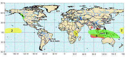
(1) An increased chance of above normal rainfall for the eastern Indian Ocean / Maritime Continent
(2) An increased chance of below normal rainfall in the central Pacific Ocean
(3) An increased chance of below normal rainfall across sections of Kenya and Tanzania
(4) An increased chance of above normal precipitation, stron winds, and high seas along the Pacific coast
(5) Tropical cyclones will impact sections of southeast Asia, Malaysia, and the Bay of Bengal
(6) An increased chance of tropical cyclogenesis in the southern Indian Ocean northwest of Australia
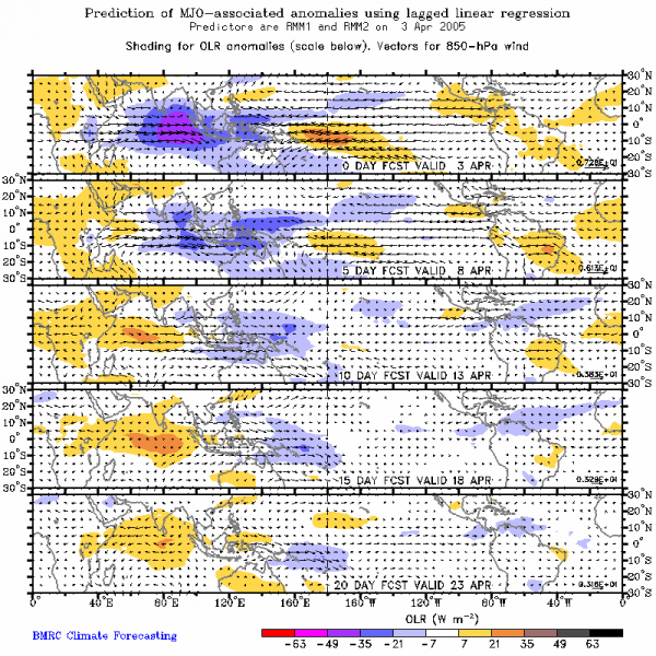
The physical basis for the Outlooks includes atmospheric responses to the ENSO cycle, the MJO, and other coherent and/or persistent modes of variability in both the tropics (atmospheric Kelvin waves, equatorial Rossby waves, etc.) and extratropics (low-latitude frontal systems, mid-latitude blocking, etc.). Several tools are used to develop the weekly product, including regular detailed atmospheric and oceanic monitoring data, statistical MJO forecasts, dynamical forecasts from both the Global Forecast System (GFS) and the Climate Forecast System (CFS), ENSO and MJO composites, and a global synoptic-dynamic model of subseasonal variability. Figure 2 gives an example of a statistical MJO forecast that is used regularly by the hazards / benefits team.
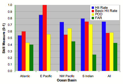
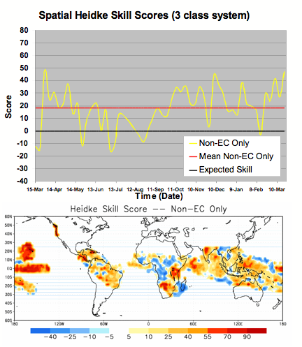
The experimental product bridges the gap between climate and weather and has many diverse applications in various sectors of the economy (including the financial, energy, agriculture, water resource management and fire weather sectors). The Outlooks also provide emergency managers and regional planners with a heads-up on potential hazards related to climate, weather and hydrologic events in the global tropics. Preliminary verification of the Outlooks for both precipitation (Figure 3) and tropical cyclogenesis (Figure 4) are encouraging, with skill levels comparable to those achieved with other CPC operational products.
Implications
Improved understanding and more realistic simulations of the MJO (including onset and demise) will have tremendous implications for assessing future potential benefits and hazards across not only the global tropics but also (at times) in the extratropics. Furthermore, quantification of potential predictability and achievable skill levels using multi-model approaches can lead to probabilistic forecasts of potential hazards. CPC’s future plans include the continued expansion of collaboration (both weekly monitoring/assessment and research) and the development of additional MJO forecasting tools.