Research Highlights
We aim to feature the latest research results from US scientists whose published paper features work that is sponsored by one or more sponsoring agency programs of US CLIVAR (NASA, NOAA, NSF, DOE, ONR). Check out the collection of research highlights below and sort by topic on the right. Interested in submitting an article for consideration? See our Research Highlight Submission Guidelines page for more information.

Wang et al. (2026) present the Wyrtki CycloStationary Linear Inverse Model (Wyrtki-CSLIM), which leverages Wyrtki and Hasselmann memory to demonstrate that skillful ENSO forecasts can be generated up to 15 months in advance using a relatively simple framework based on sea surface temperature and sea level observations.
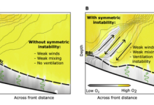
Körner et al. (2026) show that symmetric instability (SI) can drive efficient vertical exchange in the northern Gulf of Mexico, transporting oxygen and heat between surface and bottom waters. High-resolution observations show that SI can transport oxygen and heat much more efficiently than turbulence alone, helping ventilate low-oxygen bottom water and influencing coastal ecosystem health.
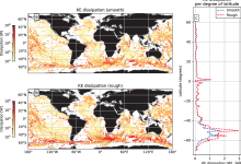
Chor et al. (2026) use turbulence-resolving large-eddy simulations to quantify how small-scale seafloor roughness on seamounts affects ocean energy dissipation and deep-water mixing, demonstrating that ignoring this roughness causes current climate models to miss roughly 30% of global seamount-driven energy dissipation—and 40% in the Southern Ocean—pointing to a clear need for improved seafloor roughness parameterizations in ocean models.
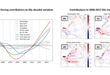
Delman et al. (2026) use an adjoint model from the observationally-constrained Estimating the Circulation and Climate of the Ocean (ECCO) state estimate to quantify surface atmospheric and hydrologic forcing to sea level, highlighting the value of observation-constrained dynamical models to asses regional sea level change, and the importance of adjoint models for attributing past variability and projecting future change.
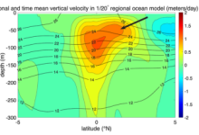
Whitt et al. (2026) use a high-resolution, eddy-resolving ocean model together with a novel method to separate mean upwelling by its driving processes to isolate and quantify the eddy-driven contribution to mean equatorial upwelling, demonstrating that eddies play a major role in shaping where water rises towards the surface on average.