The upper ocean response to atmospheric rivers
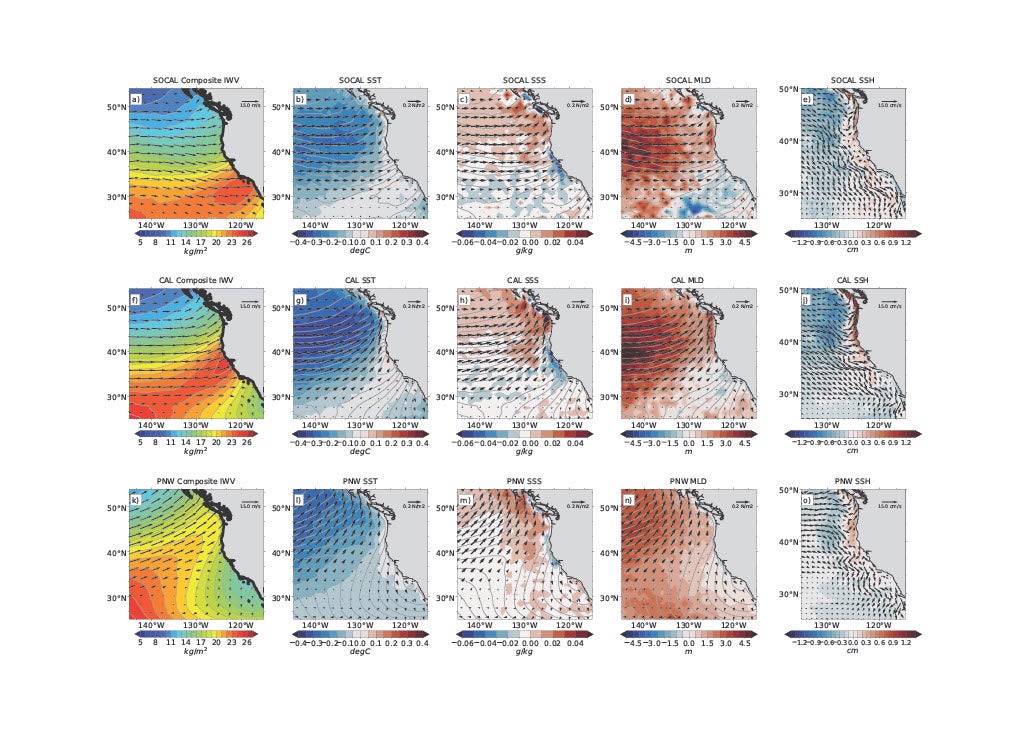
Figure 1: Historical (1966–2005) anomaly composites for SOCAL (a–d), CAL (e–h) and PNW (i–l). IWV (a, f, k, kgm−1), SST (b, g, l, °C), SSS (c, h, m), MLD (d, I, n, cm), and SSH (e, j, o, cm). 850 hPa wind vectors (ms−1) are overlaid on IWV in (a, e, f), and surface wind stress vectors (Nm−2) are overlaid on SST, SSS, and MLD. The panels (e, j, o) show the SSH and ocean surface current vectors (ms−1) on the 0.1° model grid to show more details near the coastal region. Composites show ARDT consensus tracks. Anomalies are computed using 35-year long-term climatology using monthly means. IWV composite anomalies are shown as gray contours in each panel for location reference.
The complex interaction between the atmosphere and the ocean has long been a topic among Earth system scientists. In Shields et al. (2024), the authors use a sophisticated, high fidelity Earth system model to add another layer of understanding by diagnosing the relationship between the upper ocean and atmospheric rivers (ARs). ARs are long, narrow, and meandering “rivers in the sky” that deliver water from lower to higher latitudes and are essential components of Earth's hydrological cycle. Many ARs occur over ocean basins because they tend to co-locate along the climatological storm tracks. However, to date, much of the AR impacts literature is focused on events over land and population centers due to the potential for ARs to cause major flooding or relieve drought.
This study focuses on Northeast Pacific ARs and their impact on the upper ocean. Understanding upper ocean impacts requires high fidelity to properly resolve the processes at play. Coupling an eddy-resolving ocean model to a 25km grid-spacing high-resolution atmosphere allows resolution of both ARs and ocean processes regionally and with greater accuracy.
The authors find that ARs and their strong winds cause significant upper ocean responses. For coastal communities and city planners, the most pressing discovery is that under high emissions scenarios, there is a significant increase in sea surface height along coastal locations. ARs push water in the direction of the flow, increasing sea surface heights as ARs approach and make landfall. It is important to understand that the study analyzes sea surface height and not sea level rise. Sea surface height is the height of the ocean surface measured relative to a reference level.
ARs imprint on the upper ocean is not limited to sea surface heights; they also leave their mark on the ocean mixed layer depth (essentially the part of the upper ocean that interacts most directly with the atmosphere), as well as the heat in and out of the ocean. For southern California, the dominant driver for the upstream ocean cooling is evaporation which is strongly reinforced in a warming world. For California and the Pacific Northwest, however, under high emissions scenarios, the dominant process switches to sensible heat, which is counter to historical patterns.
Response of the upper ocean to northeast Pacific atmospheric rivers under climate change (Nature Communications Earth & Environment)
Topics
- Ocean Heat
- Air-Sea
- Extreme Events
- Modeling
- Water Cycle