Can we measure global mean sea level with an array of drifting buoys?
Global mean sea level (GMSL) designates the height of the sea level averaged across the world’s ocean with respect to a reference mean sea surface. As a physical measurement, its change and especially its 20th-century rise integrates two main oceanic impacts of anthropogenic climate change: the ocean expands as its water warms and its mass increases from land ice melt. The consequences of GMSL rise are severe as it notably drives upward the frequency of extreme events related to coastal sea level rise, however these extreme events have different regional characteristics. Global mean or regional sea level are currently measured by two global ocean observing systems: the international network of coastal and island tide gauges (with some records dating back to the 19th century) and satellite radar altimeters (with the record of reference starting with the TOPEX/Poseidon satellite in 1993). The records from both systems are used to understand how GMSL has been responding to natural and anthropogenic forcings, as well as how it might further change under future climate change scenarios.
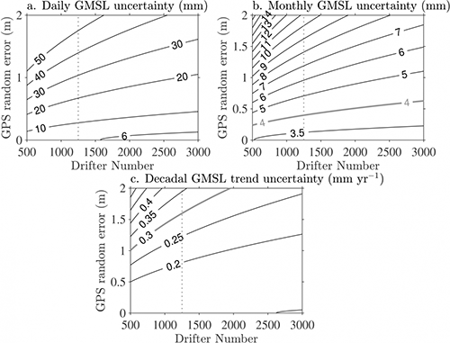
Uncertainty for drifter GMSL and GMSL trend estimates. (a) Uncertainty in mm of daily drifter GMSL estimates as a function of the number of drifters and the individual drifter GPS altitude random error. (b) Same as in (a) but for monthly drifter GMSL estimates. (c) Uncertainty in mm per year of drifter GMSL decadal linear trend based on daily estimates as a function of the number of drifters and the individual drifter GPS altitude random error. In each panel the vertical dotted line indicates 1,250, the goal number for the drifter array (click image to enlarge).
Global mean sea level (GMSL) designates the height of the sea level averaged across the world’s ocean with respect to a reference mean sea surface. As a physical measurement, its change and especially its 20th-century rise integrates two main oceanic impacts of anthropogenic climate change: the ocean expands as its water warms and its mass increases from land ice melt. The consequences of GMSL rise are severe as it notably drives upward the frequency of extreme events related to coastal sea level rise, however these extreme events have different regional characteristics. Global mean or regional sea level are currently measured by two global ocean observing systems: the international network of coastal and island tide gauges (with some records dating back to the 19th century) and satellite radar altimeters (with the record of reference starting with the TOPEX/Poseidon satellite in 1993). The records from both systems are used to understand how GMSL has been responding to natural and anthropogenic forcings, as well as how it might further change under future climate change scenarios.
In a recently published Geophysical Research Letters paper, Elipot demonstrates how a new ocean observing system for measuring sea level changes could piggy-back on the existing array of freely drifting buoys, or surface drifters, of NOAA’s Global Drifter Program (GDP). Established in 1979, one of the GDP’s objective is to maintain a 5 by 5 degree array of approximately 1,300 buoys to principally measure ocean currents near the surface and sea surface temperature. Now equipped with Global Positioning System (GPS) receivers, surface drifters report their geographical coordinates and other sensor data at hourly time steps back to data centers on land. Yet, they do not report their altitude as part of their coordinates (which they could), and Elipot demonstrates that the data with geographic coordinates plus additional proposed altitude data could be used to measure sea level locally, and globally with the entire array. This study is essentially an exercise in quantifying the uncertainties associated with measuring sea level from relatively small freely-drifting buoys: using actual historical drifter trajectories but simulated sea level data, the study demonstrates that GMSL decadal linear trend estimates with an uncertainty less than 0.3 mm yr−1 could be achieved with GPS daily random error of 1.6 m or less in the vertical direction. As a point of comparison, GMSL decadal linear trend uncertainties from altimeter data vary between 1 and 0.5 mm yr-1.
Development and implementation of such sea level measurements could ultimately provide an independent and resilient observational system to infer natural and anthropogenic sea level changes, augmenting the ongoing tide gauge and satellites records. Like the satellite record, the drifter daily record of sea level would be near global, and like the tide gauge record, it would be high frequency.
Measuring global mean sea level changes with surface drifting buoys (Geophysical Research Letters)
Topics
- Observing Systems
- Sea Level Rise
- Uncertainty Quantification
- Climate Change
- Extreme Events