Extreme event deja vu: Hurricane Harvey (2017) and Louisiana flood (2016)
Hurricane Harvey made landfall in Texas as a category-4 hurricane in August 2017. The catastrophic flooding produced by Harvey damaged almost 300,000 homes, causing an enormous economic loss estimated between $90–$160 billion dollars. Apart from being an intense hurricane, what made Harvey particularly devastating was that the storm stalled near the Texas coast and produced heavy rains for four consecutive days near Houston. The intense rainfall over several days was reminiscent of the Louisiana flood that occurred a year earlier. In that August 2016 event, a stalled low-pressure system produced four days of intense rainfall that devastated the city of Baton Rouge.
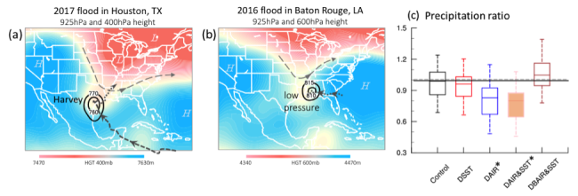
The two events bear a striking resemblance not in the storm category but rather in the time of year that they occurred (August), as well as in their geographical location (neighboring states and near-coastal cities). Both systems had stalled due to blocking high pressure that prevented movement further inland followed by interactions with a frontal system to the north. While the Gulf Coast is no stranger to storms, any tropical cyclone that stalls for days over a major metropolitan area is a recipe for disaster. A new study, in Environmental Research Letters, conducted a quantitative attribution on the impact of long-term climate trends on the heavy precipitation associated with Harvey through regional simulations forced by various sets of lateral boundary conditions, including those with the long-term trends altered.
Quantitative attribution conducted by regional model downscaling simulations, with the climate trends removed from the input data, suggest that post-1980 warming in both the ocean and atmosphere resulted in an estimated 20% increase of the accumulated event precipitation (with an interquartile range of 13%−37%). Preliminary Earth system modeling projections of stalled storms over southwest Texas, in conjunction with approaching northern frontal systems, signifies an increasing trend in the number of cases that have similar synoptic patterns and associated stationarity to that of Harvey. Precipitation associated with these stalled storms was projected to increase due to increased precipitable water.
While the estimate from the present downscaling attribution is by no means absolute, since attributing convectively driven extreme precipitation events is challenging, this study calls for a careful reevaluation of the attribution of convective-driven systems that may become more stalled in the future and produce more rainfall.
Quantitative attribution of climate effects on Hurricane Harvey's extreme rainfall in Texas (Environmental Research Letters)
1Utah State University
2Chines Academy of Sciences, China
3Gwangju Institute of Science and Technology, South Korea
4Colorado State University
Topics
- Weather
- Modeling
- Climate Change
- Air-Sea
- Hurricane
- Extreme Events