Impact and predictability of multi-year La Niña events
La Niña, a recurrent cooling pattern over the tropical Pacific Ocean, has been linked to reduced wintertime precipitation across the southern tier of the United States. Historical observations show that La Niña events can last two years or longer, a feature that could make their associated drought impacts more persistent. Two new studies published in Geophysical Research Letters show how these multi-year La Niña events affect North American climate and whether they can be predicted years in advance.
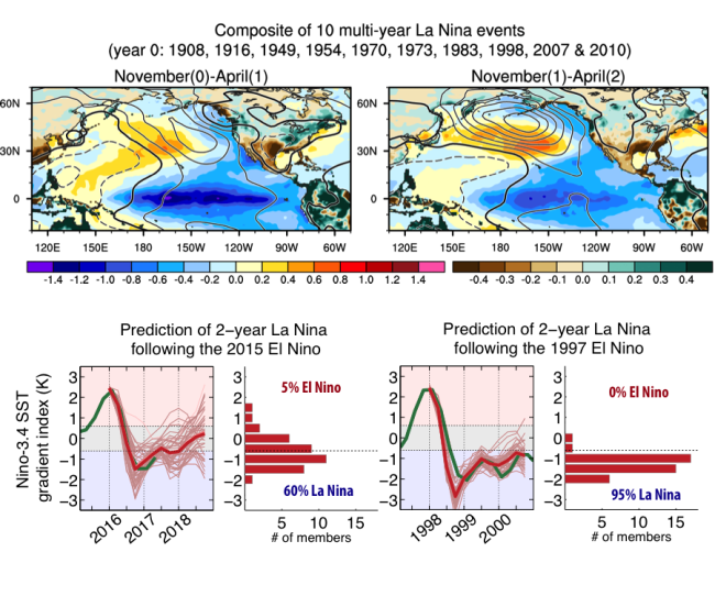
The first study explored the temporal evolution of atmospheric circulation and US precipitation anomalies during multi-year La Niña events. The equatorial Pacific cooling associated with La Niña typically weakens from the first to the second winter, but the drought impacts over the southern US do not recede, according to an analysis of historical observations. US precipitation deficits remain large in the second winter while the region of reduced precipitation shifts northeastward. Atmospheric circulation anomalies over the North Pacific become even stronger in the second winter relative to the first winter. This paradox is caused by subtle changes in the pattern of tropical Pacific cooling. During the second winter, the tropical Pacific cooling weakens in a narrow band along the equator but becomes meridionally broader. The broader cooling appears more effective at influencing the large-scale atmospheric circulation.
Despite their outsized impacts on drought, little is known about the predictability of these multi-year La Niña events. The second study addresses this issue by using a suite of decadal prediction experiments performed with a climate model capable of simulating multi-year La Niña events. The model showed remarkable skill in predicting the occurrence of multi-year La Niña events that were preceded by strong and moderate El Niño. This study showed that the predictability of La Niña duration is controlled by the magnitude of initial oceanic heat content anomalies driven by the preceding El Nino. These results permitted the prediction of the duration of the ongoing La Niña event. The forecasts, initialized in November 2015 at the peak of the record-breaking 2015-16 El Niño event, provide a 60-80% probability of returning La Niña for the upcoming 2017-18 winter.
These new findings can potentially improve the ability to predict both the strength and duration of US droughts caused by La Niña.
*Evolving impacts of multiyear La Niña events on atmospheric circulation and U.S. drought (Geophysical Research Letters)
**A 2-year forecast for a 60-80% chance of La Niña in 2017-2018 (Geophysical Research Letters)
1University of Texas at Austin
2NCAR
Topics
- Weather
- Modeling
- Air-Sea
- ENSO