Modeling western North Pacific tropical cyclones associated with ENSO
The western North Pacific is the most active basin of the global oceans with the highest annual number of tropical cyclones. It is well known that the El Niño–Southern Oscillation (ENSO) strongly affects the interannual variability of these tropical cyclones. Previous observational studies show that western North Pacific tropical cyclone activity is above normal during El Niño years and below normal during La Niña. It is also found that there are differences in the tropical cyclone activity between eastern Pacific El Niño and central Pacific El Niño. In assessing the feasibility of dynamical seasonal forecast of tropical cyclones, it would be relevant to know whether state-of-art global climate models can simulate the western North Pacific tropical cyclone response to different types of ENSO.
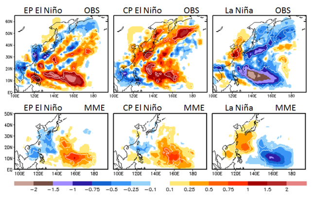
With a primary focus on modeling studies of tropical cyclones, the US CLIVAR Hurricane Working Group initiated a set of simulations with five high-resolution atmospheric global climate models—forced with the observed time-varying sea surface temperature from 1982 to 2009. A recent paper by Han et al. evaluates the performance of the five individual models, as well as a multi-model ensemble mean, in simulating the interannual variability of western North Pacific tropical cyclones associated with ENSO.
What they found is that for the annual tropical cyclone counts, the multi-model ensemble mean has the closest long-term mean value and the smallest root-mean-square error compared to the observations. Most models can reproduce the interannual variability of these cyclones well, with stronger activity during El Nino and weaker activity during La Niña. However, none of the models capture the distinctions between eastern Pacific and central Pacific El Niño as found in observations. The incapability of the models in distinguishing the differences in tropical cyclone activity between the two types of El Nino is likely due to the model biases in response to the shift of tropical heating associated with eastern Pacific and central Pacific El Niño.
An Assessment of Multimodel Simulations for the Variability of Western North Pacific Tropical Cyclones and Its Association with ENSO (Journal of Climate)
1National Climate Center, China Meteorological Administration, Beijing, China
2NOAA/NWS/NCEP/Climate Prediction Center
3Innovim
4NOAA/Geophysical Fluid Dynamics Laboratory
5Florida State University
6Goddard Earth Sciences Technology and Research, I. M. Systems Group
7Global Modeling and Assimilation Office, NASA Goddard Space Flight Center
8Lamont-Doherty Earth Observatory, Columbia University
9Columbia University and NASA Goddard Institute for Space Studies
10University of Melbourne, Victoria, Australia
Topics
- Pacific Ocean
- Modeling
- ENSO
- Hurricane