Summer 2014 winds gave the 2015-16 El Niño a head start
Following a large westerly wind burst in February 2014, buzz developed that a strong El Niño event would occur in the following winter. However, during June and July of 2014, anomalous easterly winds along the equator occurred, forestalling the developing El Niño. While temperatures remained elevated across the equatorial Pacific during the winter of 2014-15, the atmosphere never coupled to the changes in the ocean, failing to bring further westerly wind anomalies, and an El Niño did not occur.

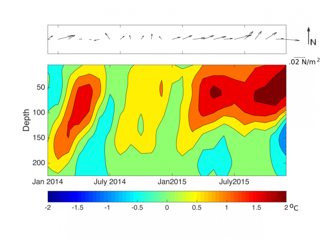
Wind stress anomalies (upper figure) and potential temperature anomalies (lower figure) averaged over 120°E-80°W, 2°N-2°S from the NOAA Global Ocean Data Assimilation System (GODAS). The unexpected easterly wind anomalies in the boreal summer of 2014 acted to maintain the warm water anomalies at depth through to the boreal spring of 2015 . This additional warm water at depth gave the 2015-16 El Niño event a head start.
The anomalous easterly winds in the boreal summer of 2014 had an additional effect. Specifically, the winds caused the anomalously warm subsurface water of the tropical Pacific—which presages an El Niño event and formed following the early 2014 westerly wind burst—to never discharge poleward, thereby remaining in the tropical Pacific. After westerly wind bursts occurred in the spring of 2015, this extra warm water acted to give a head start to the developing El Niño and contributed to the strength of the 2015-16 El Niño event.
Expanding on previous research, the authors found that when a strong easterly wind event occurs during the boreal summer of a growing El Niño event, not only does the easterly wind forcing decrease the likelihood of an El Niño event in the upcoming winter, but the same easterly wind event increases the likelihood of an El Niño event in the second winter because the anomalous subsurface warm water remains to give it a head start.
How the July 2014 Easterly Wind Burst Gave the 2015-6 El Niño a Head Start (Geophysical Research Letters)
NOAA Pacific Marine Environmental Laboratory
Topics
- Pacific Ocean
- ENSO
