The warmest January and February in the Arctic
Right from the beginning of 2016 new records were set in the Arctic: warmest air temperature on record in both January and February, and the lowest sea ice cover in February. The average temperature anomaly was a record high of 5.8°C (10.4°F) for January and 4.56°C (8.2°F) for February. This is the warmest period in the Arctic for these two consecutive months since 1948—which was the beginning of National Centers for Environmental Prediction reanalysis dataset. The Arctic sea ice extent for February 2016 averaged 14.2 million square kilometers (5.5 million square miles), the lowest February extent in the satellite record, which extends back to 1979. Once Arctic scientists at NOAA Pacific Marine Environmental Laboratory put this past January and February into historical perspective, they saw that this unusual warmth is unprecedented. This unprecedented warmth is mainly due to the large positive temperature anomalies in the Arctic Ocean and over the North American continents. The record low sea ice cover can be partially attributed to thin ice cover, from years of a declining trend, and in turn the thin ice cover could let more heat from the ocean to enter into the atmosphere. This year’s record high temperature and low sea ice cover increases concerns about what will happen next in the Arctic and globally.
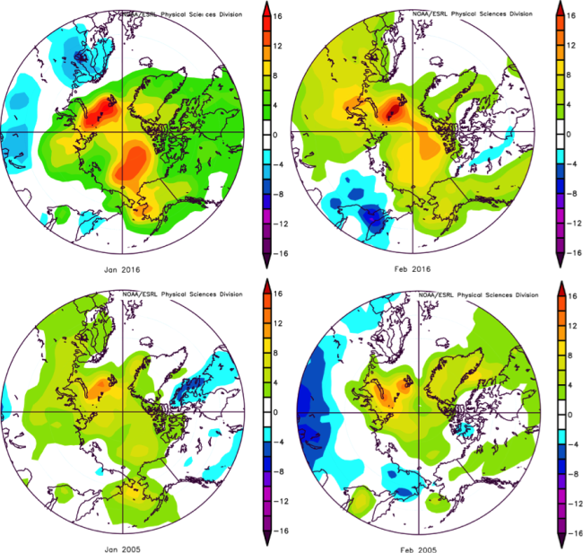
January (left) and February (right) surface air temperature anomaly over the Arctic based on NCEP/NCAR reanalysis. The top panels are for the new record year, 2016; the bottom panels are for the previous record year, 2005. The anomalies are computed relative to the 1981–2010 period mean.
1University of Washington and NOAA Pacific Marine Environmental Laboratory
Topics
- Sea Ice
- Climate Change
- Arctic