“Warm Arctic–Cold Siberia” pattern: The importance of the stratospheric circulation
Over the recent decades, adverse cold winters have occurred frequently in Eurasia, concurrent with a pronounced warming over the Arctic, and this is known as the “warm Arctic–cold Siberia” pattern. However, there is an ongoing scientific debate regarding the role of the Arctic sea ice decline on the observed cooling trend over Eurasia. While some studies attributed the observed cold anomalies to the rapid sea ice decline, especially over the Barents-Kara seas, others found no linkage between the two and attributed the cold winter events to the natural variability of the atmosphere.
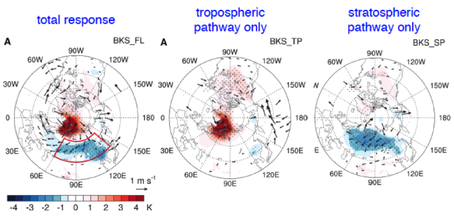
In a recent study published in Science Advances, Zhang and coauthors present a robust “cold Siberia” pattern in the winter following sea ice loss over the Barents-Kara seas region in late autumn in an atmospheric model with a well-resolved stratosphere (see left plot). Most importantly, the study explicitly demonstrates the crucial role of the stratospheric circulation in the development of cold conditions over Siberia. On one hand, the Barents-Kara seas’ sea ice loss and associated warming modifies the tropospheric wave activity and the downstream Ural ridge and East Asia trough. On the other hand, the sea ice loss leads to enhanced upward wave propagation into the stratosphere and a weakening of the stratospheric polar vortex, which further affects the tropospheric ridge and trough pattern. As the influence of the weaker stratospheric polar vortex is numerically removed, the study finds almost no cold anomaly over Siberia (see middle plot). And the downward influence of the weaker stratospheric polar vortex significantly intensifies the Ural ridge and East Asia trough, favoring more frequent cold air outbreaks and colder winters over Siberia (see right plot).
Since many previous Arctic and mid-latitude interaction studies used poorly resolved stratosphere models, this work cautions the accuracy of their conclusions and highlights the necessity to use stratosphere-resolving models. The finding also has important implications for improving seasonal climate prediction of mid-latitude winter cold events by making use of autumn Arctic sea ice conditions.
1Purdue University
2Lamont-Doherty Earth Observatory, Columbia University
3National Center for Atmospheric Research
4University of Toronto Scarborough
5University of Alaska Fairbanks
Topics
- Sea Ice
- Weather
- Modeling
- Arctic
- Air-Sea