Research Highlights
We aim to feature the latest research results from US scientists whose published paper features work that is sponsored by one or more sponsoring agency programs of US CLIVAR (NASA, NOAA, NSF, DOE, ONR). Check out the collection of research highlights below and sort by topic on the right. Interested in submitting an article for consideration? See our Research Highlight Submission Guidelines page for more information.
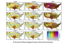
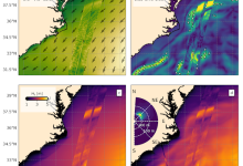
Kessenich et al. (2025) analyzes projected changes in CONUS fire weather and compares the responses of multiple fire indices using 13 dynamically downscaled regional climate models from North America CORDEX for the historical reference (1980–2010), mid-century (2030–2060), and end-of-century (2069–2099) periods.
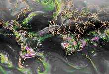
A new study by Chang et al. (2025) using unprecedented high-resolution global climate simulation ensembles highlights major advances in representing mesoscale convective systems (MCSs) over global land and provides fresh insight into their role in driving future extreme precipitation changes. These simulation ensembles–produced at 10-25 kilometer resolution–are part of a collaborative modeling effort that enables robust assessment of mesoscale processes previously inaccessible to standard 100-kilometer low-resolution global models.
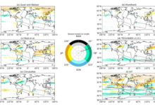
Kamnani et al. (2025) present the first systematic global assessment of how consistently different regions exhibit a dominant atmospheric river (AR) season, tracking how often regional peaks repeat across regions and detection methods. Some regions, like East Asia, show a strong peak, while other regions such as the South Atlantic, exhibit no seasonal and annual shifts. The study shows that AR seasonality inconsistencies arise both from detection-method differences and variability in atmospheric moisture transport, reshaping our understanding of AR seasonality and underscoring the important of regional context.
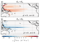
Using a local energetics framework to quantify the energy needed to lift dense subsurface waters in the equatorial Pacific and to determine its source, Brizuela et al. (2025) find that 20-50% of equatorial upwelling is not driven by local winds but by potential energy stored in the tropical thermocline. This study also finds that variations in this remote energy pathway help sustain ENSO-related changes in upwelling. This work offers a new diagnostic approach for understanding equatorial Pacific upwelling across seasonal, interannual, and decadal timescales.
Villas Bôas, Marechal, and Bohé (2025) leverage data from SWOT’s Ka-band Radar Interferometer (KaRIn) to explore the first-ever two-dimensional (2D) maps of significant wave height (Hs) at kilometer-scale resolution. These novel observations enable detailed investigation of how waves, winds, and currents interact across a wide range of scales and ocean conditions.